John Speed added a short essay which was published on the rear (the verso) of
the old map of Wiltshire which we have translated into modern English . . .
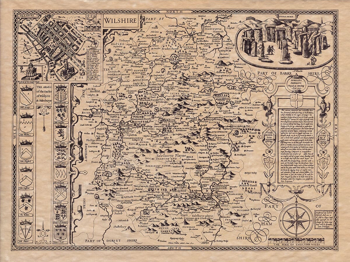
Wiltshire, formerly known in Old English-Saxon as “Wilretta,” is bordered to the north by Gloucestershire, to the east by Berkshire, to the south by Dorset and Hampshire, and to the west partly by Gloucestershire and partly by Somerset.
The county is both long and wide. From Ingleham on the Thames in the north to Burgat Damarum in the south is 39 miles. The widest part of Wiltshire is from Buttermer in the east to the Shire-Stones in the west, covering 29 miles. The total circumference of the county is 139 miles.
The climate is temperate, pleasant, and healthy, and the soil is incredibly fertile and productive, with great variety, according to John of Sarisbury.
The northern part of the county, called North Wiltshire, is hilly, with large woods and clear rivers, including the Isis River, which soon became one of the most famous in the land. The southern part of Wiltshire is flatter, producing abundant grass and grain, made even more fertile by the rivers Wily, Adder, and Avon. The center of the county, known as Salisbury Plain, is completely flat and so level that it appears to limit the horizon; it’s so flat that it’s hard to see from one side to the other. These plains are home to countless sheep, whose wool and meat bring a steady income to their owners.
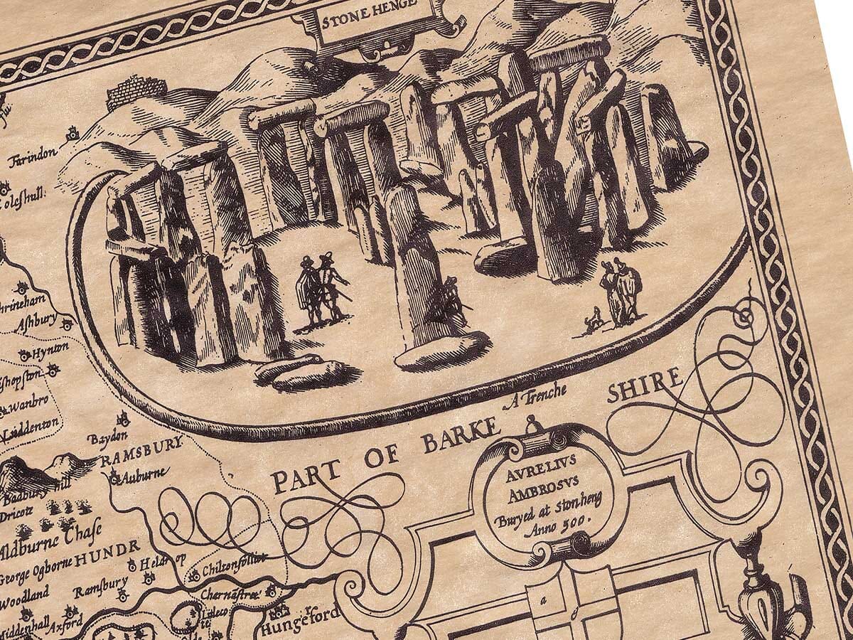
In ancient times, the Belgae, who lived in what is now Hampshire, Somerset, and Wiltshire, controlled this region. According to Ptolemy, the Belgae came from Gaul, and some believe they were conquered by Vespasian, a general under Emperor Claudius, when he laid the foundation of his future greatness through victories over the Britons. The Romans left their mark here, with remnants such as the Tanesbury Trench (believed to be Vespasian’s) and Roman coins found throughout Wiltshire, proving they settled here.
After the Romans, the West Saxons took control of the region, with the Avon River marking their border. Though the Mercians frequently encroached on their territory, leading to many battles between the two groups. Eventually, they defined their borders with a large trench crossing the middle of Salisbury Plain, called
Wansdyke, which was believed by locals to be created by the devil. This trench is named after Woden, the Saxon god and ancestor. The village of Wodensburg still retains the name. This was the site where in 590 CE, the West Saxon King Ceawlin was defeated by the Britons and forced into exile. Later, King Ina of the West Saxons fought King Ceolred of the Mercians here, with both sides suffering heavy losses. Several other major battles took place in Wiltshire, including those at Bradford, Wilton, Edindon, and at the Synod of Calne in 977, where a tragic accident occurred during heated debates over clerical celibacy, resulting in a collapsed floor that killed many nobles and prelates.
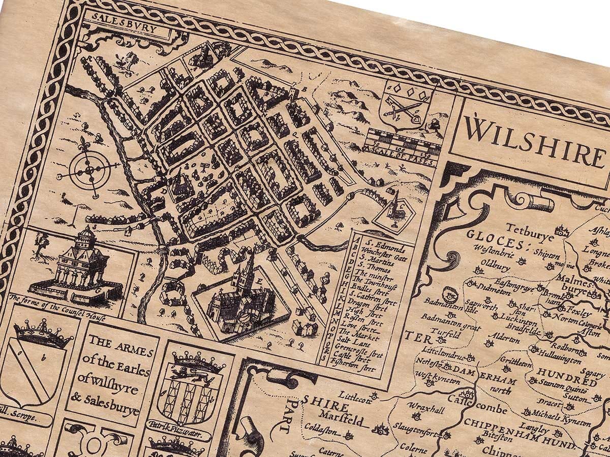
The main city of Wiltshire is Salisbury, which was relocated to a more convenient site due to its predecessor’s lack of water. Salisbury now has rivers flowing through nearly every street and is known for its magnificent buildings. The cathedral, which was begun by Bishop Richard Poor, took 40 years to complete. It is adorned with as many windows as there are days in a year, as many marble pillars as there are hours, and as many gates as there are months. Salisbury has long been an important city, with eight noble families holding the title of Earl of Salisbury since the Norman Conquest. It is currently held by Robert Cecil, the loyal and wise Lord High Treasurer of England, who is also the city’s patron. Salisbury is located at 51 degrees 10 minutes north latitude and 18 degrees 31 minutes west longitude.
Old Salisbury, also known as
Old Sarum the original site, was the location where King Kenrik of the Saxons defeated the Britons [
fable-Ed] and where Canute the Dane caused significant damage by fire. This area was once a Roman settlement, as evidenced by coins found in the area. Later, it became a center of Saxon royal power. However, the fortunes of these places have faded, as they did for many other ancient religious sites in the area, including the famous Malmesbury Abbey. The city of Malmesbury was founded by Maidulph, a learned Scot, who lived as a hermit, and his disciple, Adelme, later built a monastery there. King Athelstan endowed the abbey, and after his death, he was buried there. The historian William of Malmesbury recorded many important events for future generations, especially in relation to both the Church and the state.
Ambresbury, built by Alfritha, the wife of King Edgar, was another religious foundation. She created it as an act of atonement for her role in the murder of her son-in-law, young Edward. Queen Eleanor, the widow of King Henry III, also spent time there, renouncing royal life to become a nun. Other religious sites in Wiltshire included Lacock, Stanlege, Wilton, Ivichurch, Farnleg, Bradstoke, Briopune, and Brombore. Many of these establishments were eventually dismantled, and their wealth redistributed for more practical uses, such as the education of youth and the maintenance of estates.
Wiltshire was once defended by eight strong castles. The county has 25 market towns, and its goods are traded across 29 hundreds. There are also 304 parish churches scattered across the county.