Vintage Map of Jersey
Vintage Map of Jersey Vintage Map of Jersey Detail Cartouche Vintage Map of Jersey Detail

Vintage Map of Jersey

Price range: £39.95 through £59.95

An 18th-century French sea chart of the Island of Jersey (Channel Islands).

This is a particularly fine edition Bellin’s Jersey chart which was issued in the mid-1700s; the style, Dépôt attribution, and Paris-meridian longitude all line up with that period. In short, it’s a handsome French hydrographic chart of Jersey from the Age of Sail—made for navigation, rich in coastal hazards and seamarks, but still showing the island’s inland parishes and principal places..

  • Stunning giclée fine art print on authentically aged heavy textured paper
  • 12 Colour printing technology  •  Guaranteed to pass or exceed museum quality standards •  Free UK Courier Delivery with tracking  • International Shipping Available
  • Available in two sizes: Large: 32″ x 24″ (82 x 60cms)   Medium: 24″ x 17.5″ (61 x 44.5cms)   Sizes approximate.
+ read more

A stunning certified FINE ART PRINT on heavy textured art paper — not a poster

  • Direct from the publisher — no middlemen
  • Printed in-house in Cornwall
  • Free UK delivery — international shipping available
  • Produced to meet — and often exceed — museum-quality standards
Inspecting Vintage Map Reproduction

Fine Art Map Reproductions – Museum-Quality Printing

Unlike most online offerings, our maps are produced entirely in-house, not outsourced to print-on-demand or drop-shipping services. This allows complete control over quality while offering better value. Each map begins with a high-resolution original, carefully enhanced and printed to order using archival papers and pigment inks for exceptional clarity, depth, and longevity. Every piece is personally overseen — no map leaves our workshop unless it is of a quality we would be proud to display ourselves.

Hand hold a magnifying glass over West Cornwall Map

Authentic Old Map Paper & Accurate Colour Reproduction

Paper choice is essential to the authenticity of our maps. We use specially sourced 190gsm paper made in the UK from pure materials and traditionally pressed with natural woollen felts. This process creates a subtle, randomly textured surface that closely resembles an original antique document. Likewise the use of premium quality ink fully saturates the paper, producing remarkable clarity, depth, and historical character. Colour fastness and sharpness will remain good for in excess of 100 years!

Map in Postal Tube
Buy Old Maps Online in the UK Today Trading online since 1999

The Old Map Company of Great Britain offers a vast and carefully curated collection of the very finest expertly reproduced vintage maps. Our range includes works by renowned cartographers such as John Speed and Willem Blaeu, covering Scotland, England, and beyond. Free UK courier delivery is included, with EU, USA, and worldwide shipping available at cost and calculated at checkout. If you need assistance, our team is always happy to help you choose the perfect map.

RECENT REVIEWS

M.F. Leicestershire
M.F. Leicestershire
Very impressed . . . exceeded my expectations. My son would now like one for Christmas!
Julia Ballester
Julia Ballester
Very pleased with the quality of the map and it even arrived before it was supposed too.
Nikki
Nikki
Amazed to find the church where we married on a 400 year old map. Bought as a 1st anniversary gift.
K.H. Middlewhich
K.H. Middlewhich
I am absolutely delighted with the my antique map. It is so interesting. I would now like to purchase another Map for my sister as a Christmas present.
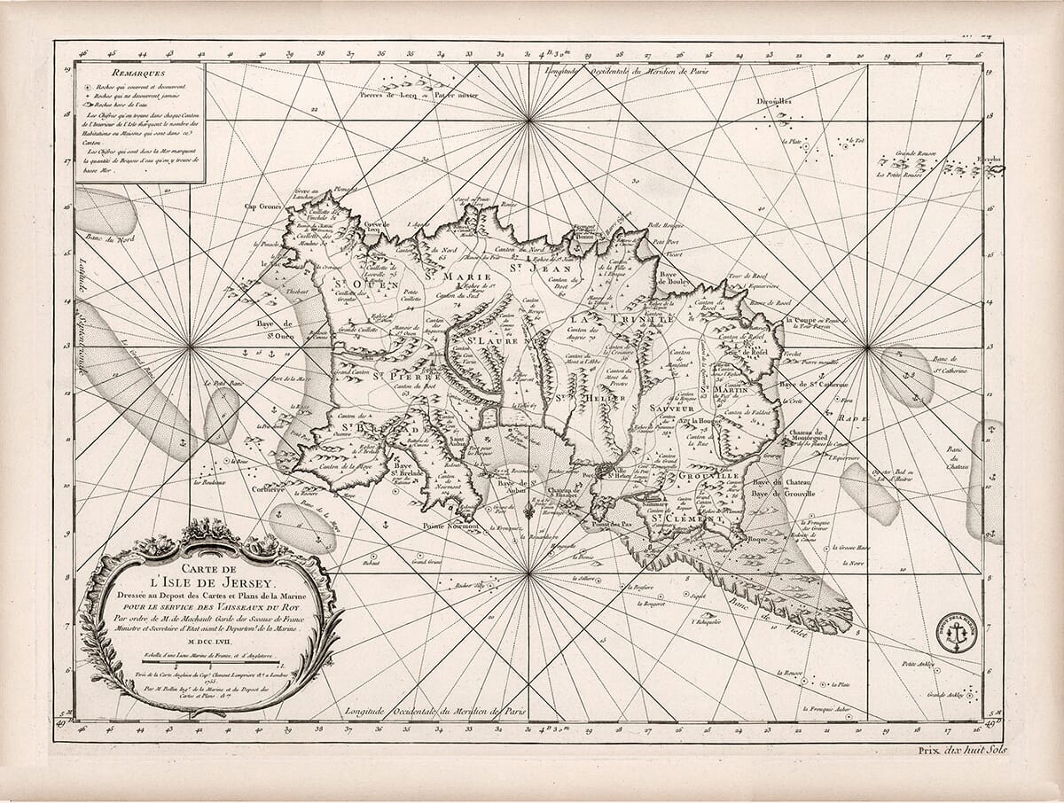
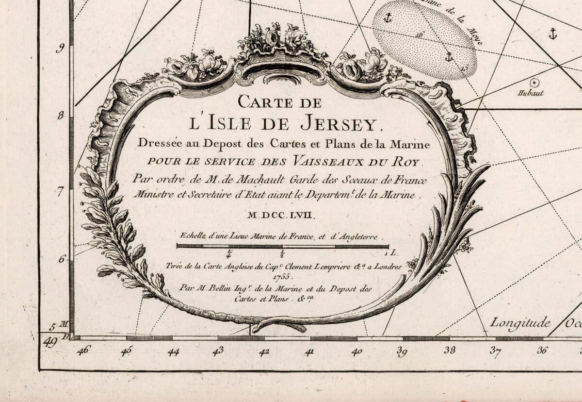
  • Title (cartouche, bottom-left): Carte de l’Isle de Jersey. Dressée au Dépôt des Cartes et Plans de la Marine… — translated: compiled at France’s naval chart office (the Dépôt de la Marine) for the use of the King’s ships. Many other Charts in this style were created by Jacques-Nicolas Bellin, the Dépôt’s chief hydrographer.

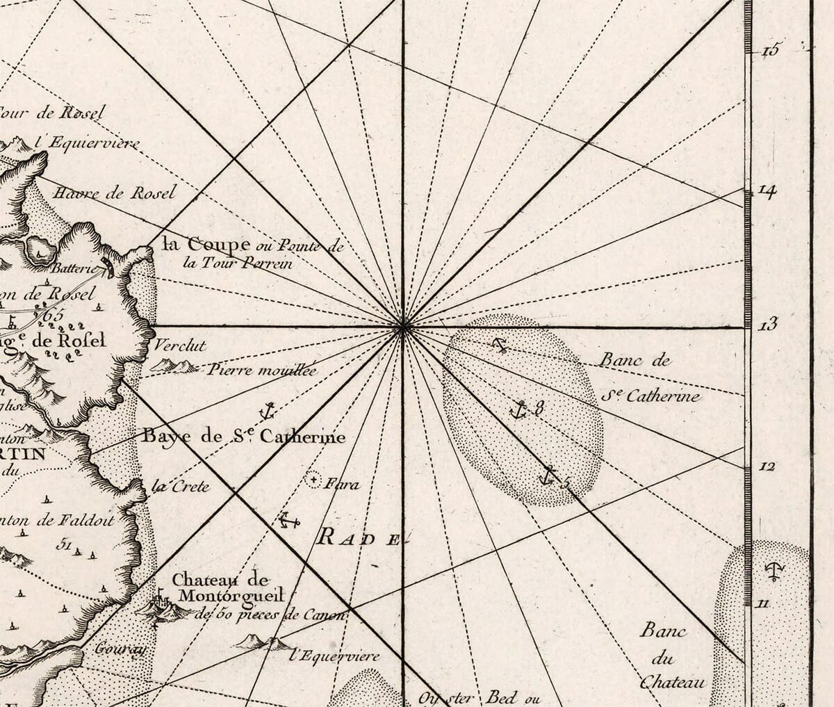
  • Purpose: It’s a nautical chart, not just a land map. Note the web of rhumb lines from several compass roses, dense soundings (water depths), anchor symbols for good holding ground, and careful shading of shoals and reefs all around Jersey (e.g., the Paternosters to the northwest and hazards off La Corbière and Grouville).

  • Language & measures: French throughout; longitude referenced to the Paris meridian (“Longitude Occidentale du Méridien de Paris”). Interstingly the depths are in French maritime units (brasses/fathoms).

  • Administrative/parish detail: The island is divided into its historic parishes—St Ouen, St Peter, St Mary, St John, La Trinité (Trinity), St Martin, St Saviour, St Helier, Grouville, and St Clement—each named on the map.

  • Forts & anchorages: You can pick out the Elizabeth Castle in St Aubin’s Bay near St Helier, the anchorage at St Aubin, Rozel Bay to the northeast, and other coastal batteries marked along the shore.

  • Notes panel (top-left): “Remarques” gives short sailing/approach notes for mariners.

  • Engraving & price: Copperplate engraving; at the bottom-right you can even see the printed price (“Prix dix-huit sols”), a nice period touch.

Dating: Bellin’s Jersey chart was issued in the mid-1700s (often catalogued around 1757–1764); the style, Dépôt attribution, and Paris-meridian longitude all line up with that period.

In short, it’s a handsome French hydrographic chart of Jersey from the Age of Sail—made for navigation, rich in coastal hazards and seamarks, but still showing the island’s inland parishes and principal places. The definition is particularly fine and of a quality that would surely grace the wall of any home or office upon the island.

×
Product added to cart
No products in the cart.