Vintage Map of Berkshire
Vintage Map of Berkshire Vintage Map of Berkshire Detail Old Map Compass Rose

Vintage Map of Berkshire with a fine old Compass Rose

Price range: £35.55 through £59.95

Vintage Map of Berkshire by John Speed c.1611

This map is a fine quality reproduction of an early-seventeenth-century county map of Berkshire, England—spelled here “Barkshire Described.” It follows the celebrated design by the English cartographer John Speed, engraved by Jodocus Hondius and first published in Speed’s atlas, The Theatre of the Empire of Great Britaine (1611–12). Hand coloured impressions of the map appeared throughout the later 1600s, and this rendering preserves the look and feel of those editions. Worthy of note is the particularly fine compass rose.
  • Stunning giclée fine art print on authentically aged heavy textured paper
  • 12 Colour printing technology  •  Guaranteed to pass or exceed museum quality standards •  Free UK Courier Delivery with tracking  • International Shipping Available
  • Available in three sizes: Large: 24″ x 25″ (61 x 63.7cms)   Medium: 18″ x 20″ (45.5 x 51cms)  Small 17″ x 18″ Sizes approximate.
+ read more

A stunning certified FINE ART PRINT on heavy textured art paper — not a poster

  • Direct from the publisher — no middlemen
  • Printed in-house in Cornwall
  • Free UK delivery — international shipping available
  • Produced to meet — and often exceed — museum-quality standards
Inspecting Vintage Map Reproduction

Fine Art Map Reproductions – Museum-Quality Printing

Unlike most online offerings, our maps are produced entirely in-house, not outsourced to print-on-demand or drop-shipping services. This allows complete control over quality while offering better value. Each map begins with a high-resolution original, carefully enhanced and printed to order using archival papers and pigment inks for exceptional clarity, depth, and longevity. Every piece is personally overseen — no map leaves our workshop unless it is of a quality we would be proud to display ourselves.

Hand hold a magnifying glass over West Cornwall Map

Authentic Old Map Paper & Accurate Colour Reproduction

Paper choice is essential to the authenticity of our maps. We use specially sourced 190gsm paper made in the UK from pure materials and traditionally pressed with natural woollen felts. This process creates a subtle, randomly textured surface that closely resembles an original antique document. Likewise the use of premium quality ink fully saturates the paper, producing remarkable clarity, depth, and historical character. Colour fastness and sharpness will remain good for in excess of 100 years!

Map in Postal Tube
Buy Old Maps Online in the UK Today Trading online since 1999

The Old Map Company of Great Britain offers a vast and carefully curated collection of the very finest expertly reproduced vintage maps. Our range includes works by renowned cartographers such as John Speed and Willem Blaeu, covering Scotland, England, and beyond. Free UK courier delivery is included, with EU, USA, and worldwide shipping available at cost and calculated at checkout. If you need assistance, our team is always happy to help you choose the perfect map.

RECENT REVIEWS

M.F. Leicestershire
M.F. Leicestershire
Very impressed . . . exceeded my expectations. My son would now like one for Christmas!
Julia Ballester
Julia Ballester
Very pleased with the quality of the map and it even arrived before it was supposed too.
Nikki
Nikki
Amazed to find the church where we married on a 400 year old map. Bought as a 1st anniversary gift.
K.H. Middlewhich
K.H. Middlewhich
I am absolutely delighted with the my antique map. It is so interesting. I would now like to purchase another Map for my sister as a Christmas present.
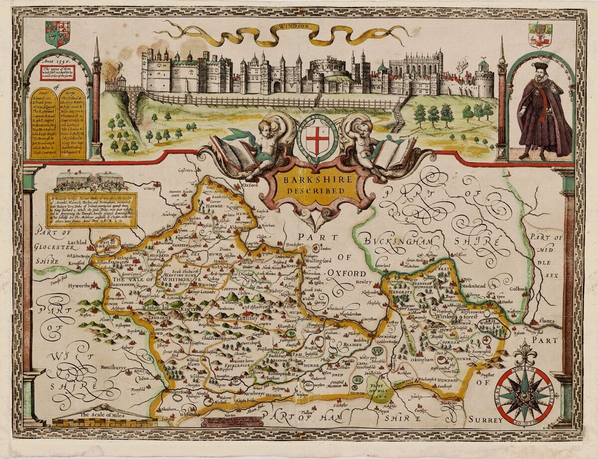
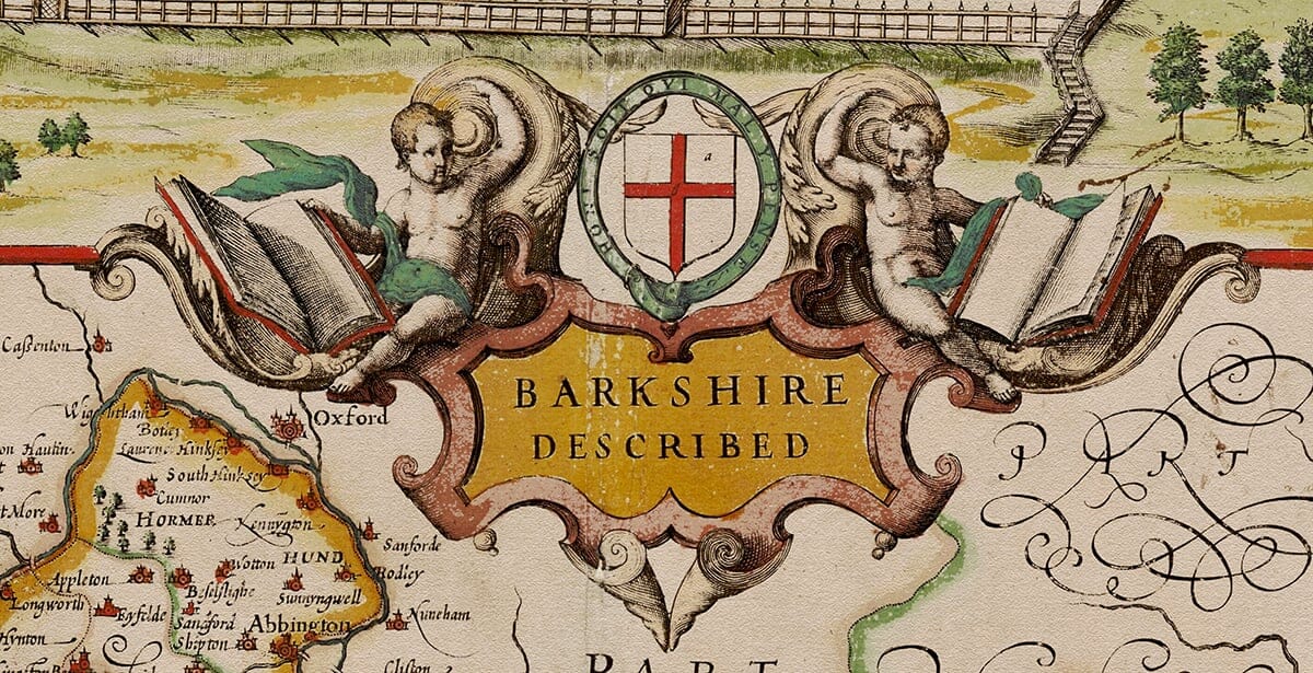
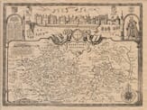
Across the top runs a sweeping panorama of Windsor, with a ribbon naming the town and a detailed prospect of Windsor Castle and its environs. At centre is a richly worked strapwork title cartouche bearing St George’s cross, flanked by cherubs and complemented by coats of arms in the corners. A side panel records the Earls of Berkshire, underlining the map’s antiquarian connection and its interest in functional detail as well as landscape features. 
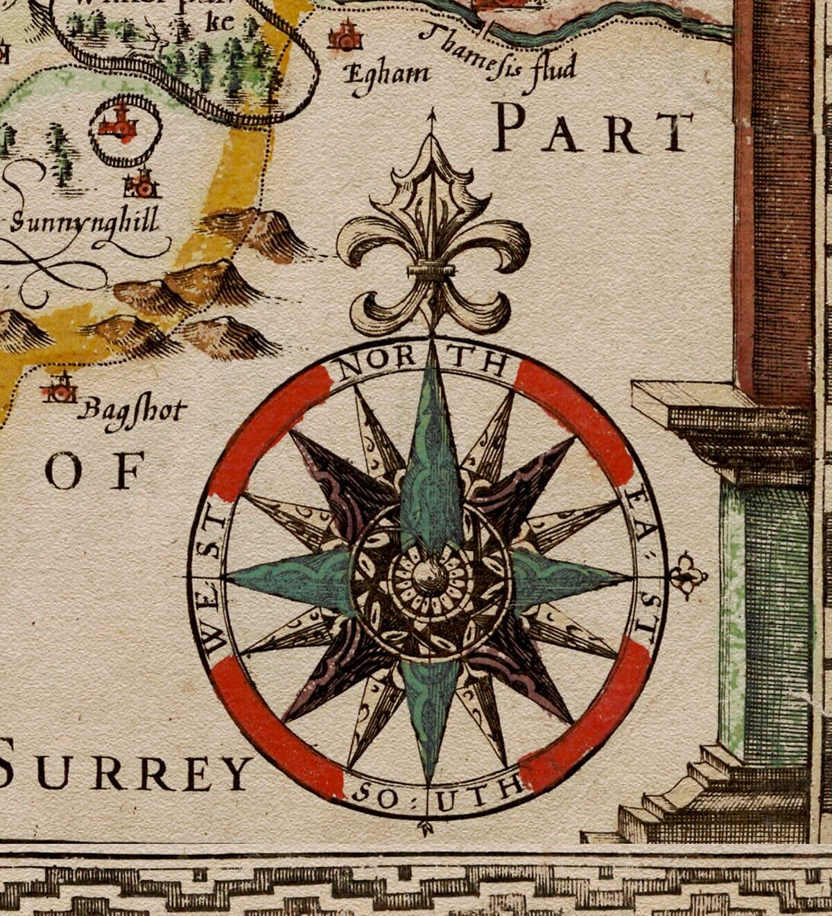
The county is shown within its historical neighbours Oxfordshire, Buckinghamshire, Gloucestershire, Wiltshire, Hampshire, Surrey, and Middlesex while within the boundary the coloured divisions mark the hundreds, the administrative districts of the period. Settlements are depicted with spires and roundels and feature profusely, from Reading, Abingdon, and Newbury to Hungerford and many smaller villages. Wooded tracts appear as neat clusters of trees, hills as the characteristic “molehills”. The lower right edge contains a particularly attractive compass rose while to the left an attractively framed scale of miles is featured. Speed’s county maps were the first widely available, consistently designed survey collection of England and Wales, combining remarkably accurate cartography for the period with added historical notes and theatrical embellishment such as town views, costumes, and heraldry. This vintage map of Berkshire exemplifies this combination of geography and early print art, celebrating Windsor and the county’s noble associations while offering a remarkably detailed portrait of the landscape as it was in the early Stuart age.

You may also like…

×
Product added to cart
No products in the cart.