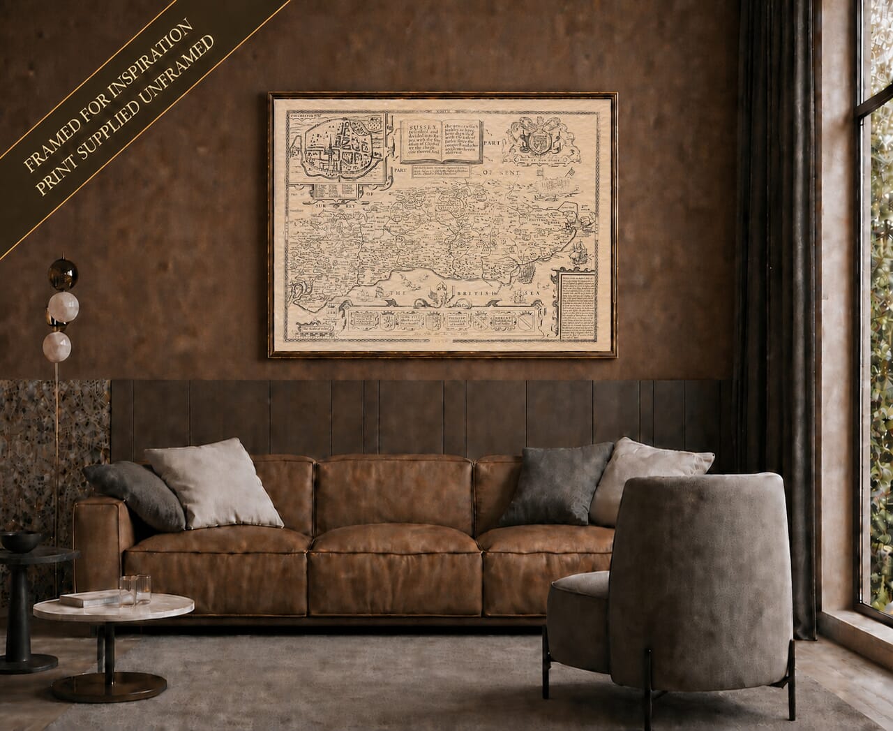
John Speed’s Map of Sussex
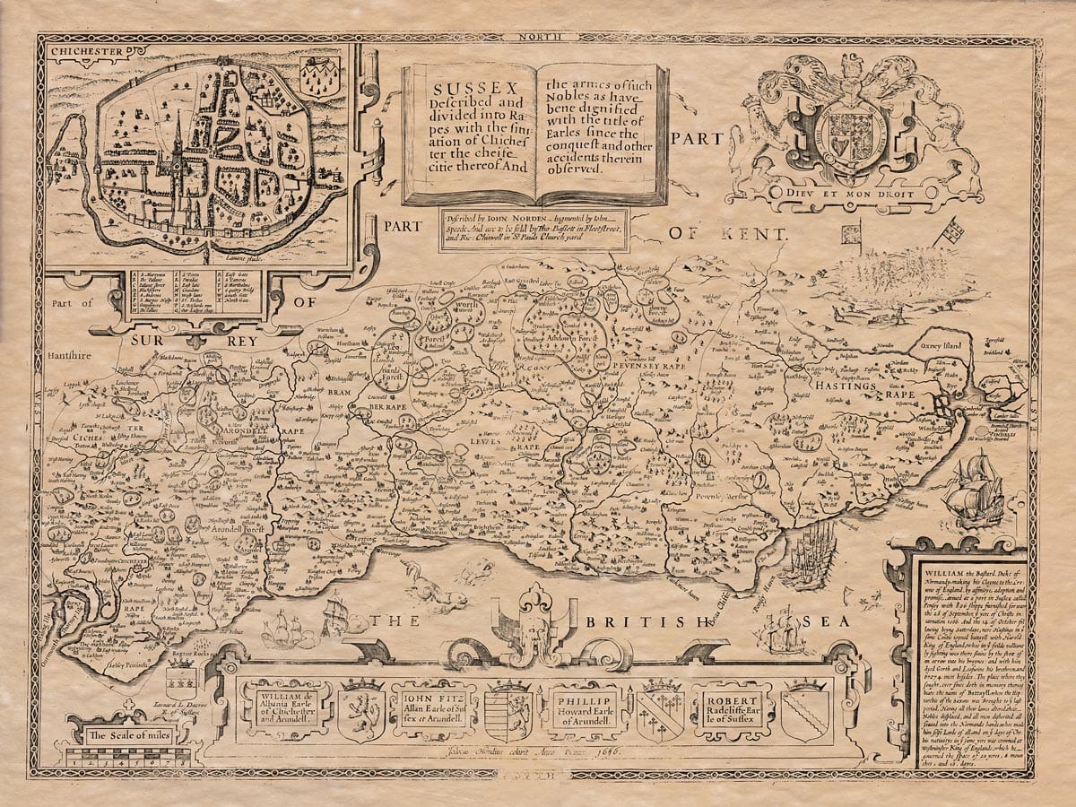
John Speed’s Sussex map is one of the most elaborate county plates prepared for his great atlas The Theatre of the Empire of Great Britaine. The original map appeared with the atlas in 1611. The reproduced sheet carries the later date 1666 and the Bassett and Chiswell publisher imprint. Importantly, the engraving tells us directly how it was created: Sussex was described by John Norden, augmented by John Speed and engraved by Jodocus Hondius.
Map Details
Original title: Sussex Described and divided into Rapes with the situation of Chichester the cheife citie thereof
Original survey and geographical source: John Norden
Cartographer and compiler: John Speed
Engraver: Jodocus Hondius
Date on reproduced plate: 1666
First atlas publication: London, 1611
Atlas: The Theatre of the Empire of Great Britaine
First-edition publishers: John Sudbury and George Humble
Inset: Plan of Chichester
County divisions: Chichester, Arundel, Bramber, Lewes, Pevensey and Hastings Rapes
Decorative features: Open-book title cartouche, Royal Arms, arms of Sussex nobility, ships, sea monsters and historical scenes
Technique: Copperplate engraving
Reproduced publisher state: Thomas Bassett and Richard Chiswell; associated with their London atlas edition of 1676
John Norden and John Speed
Speed did not pretend that the geographical work was entirely his own. The map itself prominently states “Described by Iohn Norden” and “Augmented by Iohn Speede.”
John Norden had carried out important county surveys before Speed began work on The Theatre. Speed used that geographical foundation, adding his own material and arranging it within the highly decorative format for which his county maps became famous. Jodocus Hondius then engraved the plate.
This explicit attribution is particularly useful today because it allows the origins of the map to be traced from the evidence engraved directly onto the sheet rather than relying upon later assumptions about authorship.
Sussex Divided into Six Rapes
Across the map Sussex is divided into its six historic Rapes: Chichester, Arundel, Bramber, Lewes, Pevensey and Hastings.
These long-established administrative divisions give Speed’s map a geography quite different from modern East and West Sussex. Each Rape was itself divided into Hundreds, and Speed’s accompanying county description records them in considerable detail.
The divisions also make the map especially rewarding for anyone researching local or family history. Familiar towns sit among a dense network of smaller villages, estates, woods and settlements whose relative importance was very different in the early seventeenth century.
Chichester in 1610
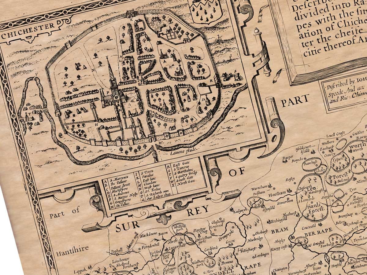
The inset plan of Chichester is one of the outstanding features of the map.
The Catalogue of British Town Maps dates the plan to 1610 and records it as covering the whole built-up area of the city. Ordinary houses are represented pictorially, while important public and religious buildings receive greater emphasis. Town gates, walls, roads and orchards are also shown.
A lettered key identifies individual features within the city. Among those recorded are streets, churches, St Mary’s Hospital, the Bishop’s Palace and the principal town gates.
For anyone interested in Chichester, this small inset is therefore almost a map within a map: an unusually detailed picture of the city at the beginning of the seventeenth century.
The Open-Book Title
At the top of the sheet Speed placed the long title inside an unmistakable open-book cartouche.
This is one of the easiest features by which the Speed Sussex map can be distinguished from later county maps by Blaeu and other publishers. Contemporary examples and specialist catalogues specifically identify this open-book design as a feature of the plate.
The title also explains Speed’s intentions unusually fully, referring not only to Sussex and its Rapes but to Chichester, the arms of the county’s noble families and the historical events represented elsewhere on the engraving.
Sussex and the Norman Conquest
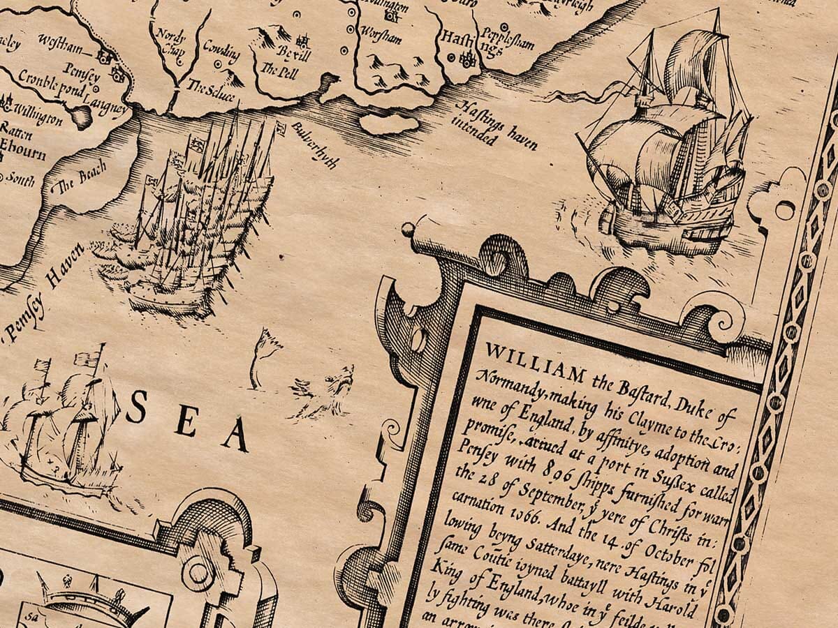
Speed used the map to connect the county with perhaps the most famous event in its history: the Norman invasion of 1066.
An engraved historical panel describes William of Normandy’s arrival at Pevensey and the subsequent battle with Harold. Speed was therefore doing more than mapping contemporary Sussex; he was deliberately placing the county within the wider history of England. The original atlas page preserves this account alongside the map.
The subject is particularly appropriate here. Pevensey, Hastings and Battle all lie within the geographical story represented on the sheet, allowing the events familiar from English history to be related directly to their Sussex landscape.
Heraldry, Ships and Sea Monsters
Speed filled the remaining space with decoration rather than leaving the sea and margins empty.
The Royal Arms occupy a prominent position, while a succession of heraldic shields records nobles associated with the county. Offshore, sailing vessels and sea creatures enliven the Channel and balance the densely engraved landscape inland. These elements are present on documented examples of the Sussex plate and were characteristic of the visual appeal of Speed’s county maps.
They also help explain why Speed’s maps have remained popular for more than four centuries: the map operates simultaneously as geography, local history, genealogy and decorative engraving.
A Map Dated 1610 — Published in 1611
There is a small but worthwhile distinction between the dates 1610 and 1611.
The copperplate itself carries the inscription “Anno Domini 1610”, the year in which Hondius engraved it. Speed’s completed Theatre of the Empire of Great Britaine was first published in 1611.
For that reason, Old Map of Sussex by John Speed, 1610 is an accurate description of the map design, while the historical text can properly explain that its first atlas publication followed in 1611.
Speed’s Description of Sussex
Speed accompanied the map with a substantial written account of the county, covering Sussex geography, its Saxon and Norman history, towns, battles and its division into Rapes and Hundreds.
Notes to the Old Map of Sussex were added by the map maker John Speed . . .
Suthsexe, a word compounded of the site thereof Southward; and of the saxons, whose Kingdom was the second in their Heptarchie, is by them Suth Seaxe, and by us Sussex, lieth stretched along the British Seas. The North confronts upon Surrey and Kent, and the West butteth upon Hampshire.
See also >
For form it lieth long and narrow, for that all her Rapes [county subdivisions] do run quite through the shire, and containeth from West Harting in the West, to Kent Ditch that divides it from Kent in the East, 64 Miles, but in the broadest part little above 20, the whole in circumference, about 158 miles.
The air is good, though somewhat clouded with mists, which arise from off her south bordering sea, who is very prodigal unto her for fish and sea-fowl, though as sparing for harbours or ships arrivage, and those which hath, as uncertain for continuance, as dangerous for entrance.
Rich is the soil and yieldeth great plenty of all things necessary, but very ill for travellers, especially in the winter, the land lying low, and the ways very deep, whose middle tract is garnished with meadows, pastures and cornfields: the sea coast with hills which are called the Downs, abundantly yielding both grain and grass, and the north side overshadowed with pleasant groves and thick woods, where sometimes stood the famous wood Andradswald, containing no less than 120 miles in length, and 30 in breadth, taking the name of Anderida, a City adjoining: both which were won from the Britains by Ella the first Saxon King of this Province, and the place made fatal to Sigebert King of the West Saxons, who being deposed from his Royal Throne, was met in this Wood by a swineherd, and slain in revenge of his Lord, whom Sigebert had murdered.
The ancient Inhabitants of Sussex.
The ancient people in the Romans time were the Regni, of whom we have spoken, and who were subdued by Vespasian the Leader of the second Legion under Aulus Plautius, Lieutenant in Britain for Claudius the Emperor. But after the departure of the Romans, this, with Surrey, was made the South-Saxons Kingdom: Suflex subdued yet that giving place to the Weft-Saxons, as they in time to the Normans, it became a Province under the Conquerors power, who gave to his followers much land in these parts to the Romans.
Chief places in Sussex.
The place of most account in this Shire is Chichester, by the Britains called Caercei, and by the Saxons Cirran Cearen, a City beautiful and large, and very well walled about, first built by Cissa the second King of the South-Saxons, wherein his Royal Palace was kept. And when King William the first had enacted that [Dioceses], should be translated out of small towns unto places of greater resort, the Residence of the Bishop (until then held at Selsey) was removed to this City, where began a most goodly Cathedral Church: but before it was fully finished, by a sudden mischance of fire was quite consumed. Yet the same Bishop, Seffrid with the helping liberality of King Henry I, began it again, and saw it wholly finished; whose beauty and greatness her fatal enemy still envying, again cast down in the days of King Richard V, and by her raging flames consumed the buildings both of it and the Bishops Palace adjoining, which Seffrid, the second Bishop of that name, reedified and built anew. And now, to augment the honour of this place, the City hath born the Title of an Earldom; whereof they of Arundel were sometimes forenamed.
Battle of Lewes 1263
With whom for frequency, bigness and building, the Town Lewes seemeth to contend, where King Athelstan appointed the Mintage of his Moneys, and William de Warron, built a strong Castle, whereunto the disloyal Barons of King Henry the Third in warlike manner resorted, and fought a great battle against their own Sovereign and his Son, wherein the King had his horse slain under him, Richard King of the Romans surprized and taken in a windmill, and Prince Edward delivered un to them upon unequal conditions of peace. But A Battle at a greater Battle was fought at Battle, when the hazard of England was tried in one days fight, and Harold the King gave place to his Conqueror by losing of his life, among sixty seven thousand, nine hundred seventy four English men besides; whose blood so spilt gave name to the place, in French, Sanguelac. And the soil naturally after rain becoming of a reddish colour, caused William of Newbery untruly to William Newbery wrote, That if there fell any small sweet showers in the place, where so great a slaughter of the English men was made, presently sweateth forth very fresh blood out of the earth, as if the evidence there of did plainly declare the voice of blood there shed, and cried still from the earth unto the Lord.
This County is principally divided into six Rapes [county subdivisions], every of them containing a River, besides the several Hundreds whereunto they are parted, that is, the Rape of Chichester into seven, of Arundel into five, of Bramber into ten, of Lewes into thirteen, of Pevensey into seventeen, and of Hastings into thirteen, in all fifty six, wherein are seated ten castles, nineteen market towns, and three hundred and twelve Parish Churches.





 Verified owner