John Speed added a short essay which was published on the rear (the verso) of the old map of Huntingdon which we have translated into modern English . . .
HUNTINGTONSHIRE
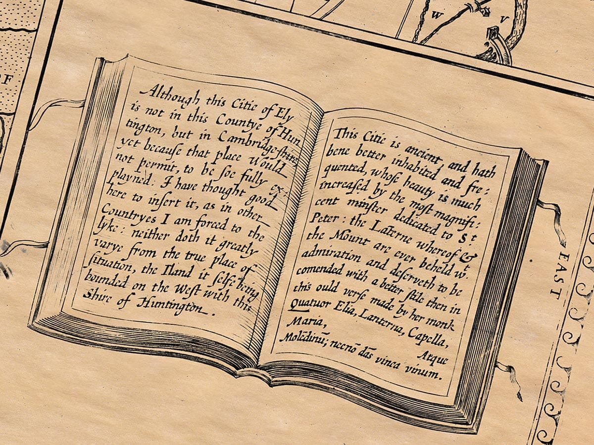
Huntingdonshire, formerly known as Hundedune (part of the Iceni tribe under the Roman rule of Mercia during the Saxon Heptarchy), is bordered by the River Nene to the north (which also forms part of Northamptonshire), and is adjacent to Bedfordshire and Cambridgeshire to the south, and Ely to the east. The county is naturally separated by a body of water, known as the Benwick Stream, and possibly enhanced by human efforts (Canutus Delph, or the “Canute Ditch”). It was part of the realm shared by King Alfred or possibly even earlier by Offa, the king of Mercia, who divided land among principalities.
In the early years, the country was covered by forests, which were eventually managed and regulated by the kings, including laws enacted by King Canute to regulate hunting and the management of wild beasts. The king’s forest laws were of great importance, and during the reign of Henry I, forest jurisdiction was formalized and enforced by forest officials known as “Forest Justices,” tasked with ensuring that the king’s laws were followed in relation to hunting, timber, and forestland.
In the 12th century, the forest boundaries and the land administration were revisited by Henry II, and this continued into the reign of his son, Henry III. Land was assessed in terms of “Hides” (a unit of land measurement), and the assessment system involved counting acres based on the quality and productivity of the soil.
THE HUNDREDS AND PARISHES
Huntingdonshire was divided into four or sometimes five hundreds, each containing several parishes. These parishes, often measured in terms of “Hides” or plough-lands, were further subdivided into areas based on the strength of the lordship or the fertility of the land. A “Hide” was generally understood to be 100 acres, but the actual number could vary depending on location.
Each of these parishes also had markets, and some were measured in “Virgates” or “Yardlands,” which represented a fraction of the land assessed in “Hides.” This method of land measurement was standardized across most of England, except in a few places like Kent and Lincolnshire, which used different systems.
GOVERNANCE AND COURTS
Huntingdonshire’s legal and administrative structure was complex, with several levels of justice administered by various figures. Initially, local issues were handled by the “Hundred Court,” where civil and minor criminal matters were judged by the local freemen or barons. The next level of court was the county or sheriff’s court, where more serious cases were heard, often involving the local Earl or Sheriff.
Higher judicial matters, including more serious civil cases and ecclesiastical disputes, were handled by the king’s court or specialized royal officers. Courts were held regularly, and the system of “view of frankpledge” (a form of communal responsibility) and “sessions of the peace” continued to operate throughout this period.
HUNTINGTON – THE COUNTY TOWN
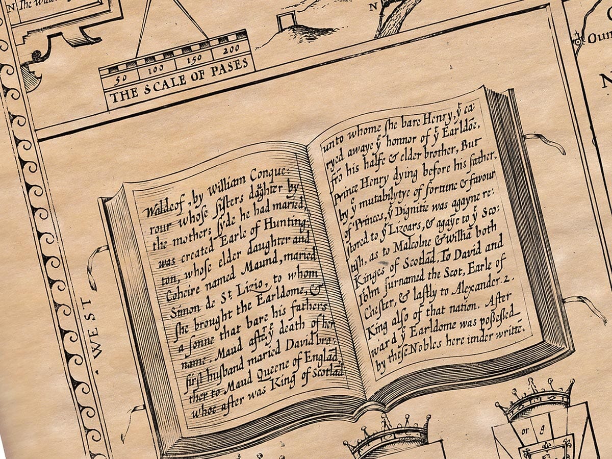
Huntington, the main town of the county, was strategically located on a hill overlooking the river Ouse. It was known as “Hundredown” or “Hunters’ Down,” a name reflecting its history tied to hunting. By the time of the Conqueror, it was divided into four wards, with significant market activity and responsibility for the local administration. It was the site of many royal charters and had a history of royal influence, including the establishment of a hospital by David, Earl of Huntington, and later the development of religious institutions, such as the Priory of Black Channons and the establishment of a hospice.
The town was known for its strong economic and political importance, with annual elections and governance by two Bailiffs. It held significant autonomy, with its own seal and a long history of royal support.
OTHER HISTORICAL NOTES
The region saw numerous religious foundations, such as the Monastery of Ramsey, which grew wealthy and influential through land donations and royal favor. In time, however, these religious estates were dissolved, often due to political or financial pressures. Many of these sites, like the monastery at Ramsey, contributed to the local economy and were centers of learning and charity.
Ramsey itself was founded in the 10th century by Earl Aylwin and grew to encompass hundreds of acres of land. Over time, it became a center of power, with the abbey and its leaders holding significant influence in the region, until it was ultimately dissolved during the reign of Henry VIII.