Captain Cook Discoveries
Captain Cook Discoveries New Zealand Old New Zealand Map

Cook’s Voyages of Discovery Map c.1767

Price range: £35.55 through £59.95

by Antonio Zatta

A rare and historical Cook’s Voyages of Discovery Map (c. 1767), a stunning example of 18th-century cartography. This unique map, created by the renowned Venetian cartographer Giovanni Antonio Zatta, showcases the routes and newly discovered lands explored during Captain James Cook’s legendary expeditions.One of the earliest pictorial maps detailing the travels of the Endeavour which is illustrated at the base of the map. Also included are the routes of Samuel Wallis, Philip Carteret and John Byron.
  • Stunning giclée fine art print on authentically aged heavy textured paper
  • 12 Colour printing technology  •  Guaranteed to pass or exceed museum quality standards   •  Free UK Courier Delivery with tracking
Available in two sizes: Large: 24″ x 31″ (61 x 78.7cms)   Medium: 18″ x 24″ (45.5 x 61cms) 
+ read more

A stunning certified FINE ART PRINT on heavy textured art paper — not a poster

  • Direct from the publisher — no middlemen
  • Printed in-house in Cornwall
  • Free UK delivery — international shipping available
  • Produced to meet — and often exceed — museum-quality standards
Inspecting Vintage Map Reproduction

Fine Art Map Reproductions – Museum-Quality Printing

Unlike most online offerings, our maps are produced entirely in-house, not outsourced to print-on-demand or drop-shipping services. This allows complete control over quality while offering better value. Each map begins with a high-resolution original, carefully enhanced and printed to order using archival papers and pigment inks for exceptional clarity, depth, and longevity. Every piece is personally overseen — no map leaves our workshop unless it is of a quality we would be proud to display ourselves.

Hand hold a magnifying glass over West Cornwall Map

Authentic Old Map Paper & Accurate Colour Reproduction

Paper choice is essential to the authenticity of our maps. We use specially sourced 190gsm paper made in the UK from pure materials and traditionally pressed with natural woollen felts. This process creates a subtle, randomly textured surface that closely resembles an original antique document. Likewise the use of premium quality ink fully saturates the paper, producing remarkable clarity, depth, and historical character. Colour fastness and sharpness will remain good for in excess of 100 years!

Map in Postal Tube
Buy Old Maps Online in the UK Today Trading online since 1999

The Old Map Company of Great Britain offers a vast and carefully curated collection of the very finest expertly reproduced vintage maps. Our range includes works by renowned cartographers such as John Speed and Willem Blaeu, covering Scotland, England, and beyond. Free UK courier delivery is included, with EU, USA, and worldwide shipping available at cost and calculated at checkout. If you need assistance, our team is always happy to help you choose the perfect map.

RECENT REVIEWS

M.F. Leicestershire
M.F. Leicestershire
Very impressed . . . exceeded my expectations. My son would now like one for Christmas!
Julia Ballester
Julia Ballester
Very pleased with the quality of the map and it even arrived before it was supposed too.
Nikki
Nikki
Amazed to find the church where we married on a 400 year old map. Bought as a 1st anniversary gift.
K.H. Middlewhich
K.H. Middlewhich
I am absolutely delighted with the my antique map. It is so interesting. I would now like to purchase another Map for my sister as a Christmas present.
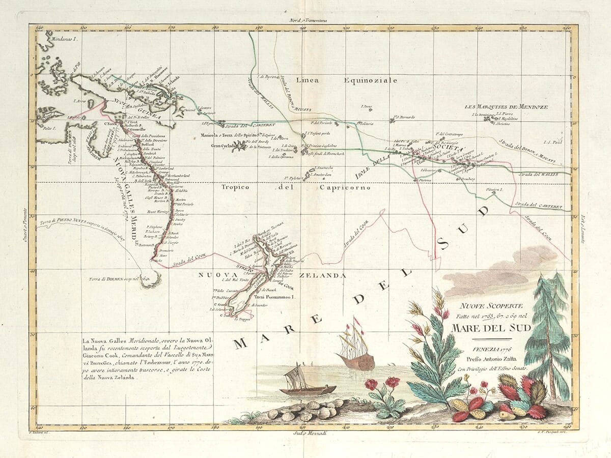
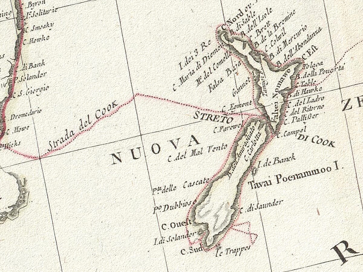
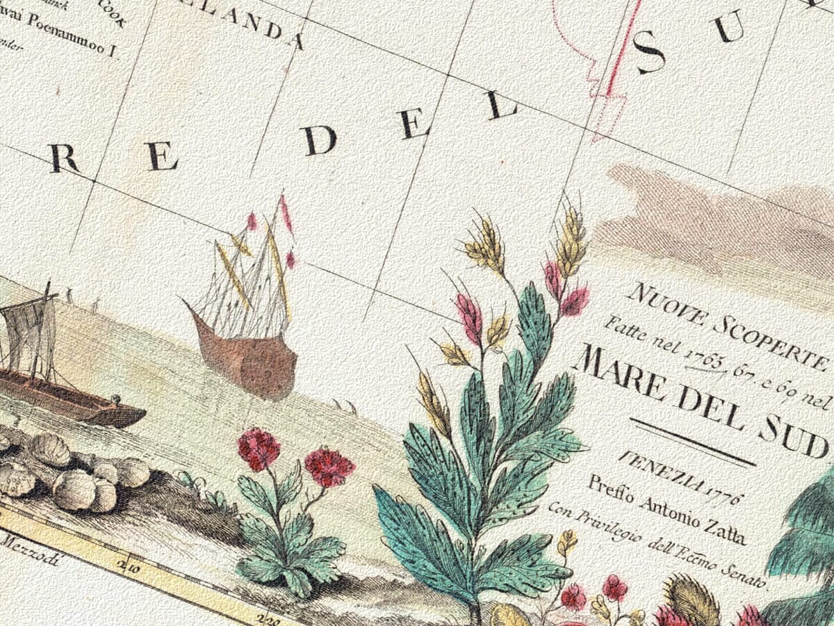
Produced around the time of Cook’s groundbreaking voyages to the Pacific, this map highlights key locations such as New Zealand, Australia, and Hawaii. Known for his exceptional craftsmanship, Zatta’s map combines precise geographical details with beautiful decorative elements typical of 18th-century maps. This historical map of Cook’s voyages is a must-have for collectors, historians, and anyone fascinated by the exploration and discovery of the Pacific Ocean. Featuring meticulously charted coastlines, islands, and annotations from Cook’s observations, this map offers a glimpse into one of history’s most important periods of global exploration. Perfect for display, study, or as a unique gift for history enthusiasts, this unusual vintage map is a valuable addition to any collection.
×
Product added to cart
No products in the cart.